
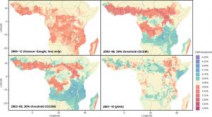
Accurate data on tree and forest cover is crucial to inform policy progress, and to investigate what drives forest change. Several products of spatial data derived from remote sensing have been made widely available in recent years. However, they have important differences, which can yield significantly divergent results when used for inference.
This paper compares several map sources in the context of African precolonial institutions, by estimating the average forest/tree cover and deforestation values over similar periods. Estimations from each product differ and the paper suggests several reasons for divergence, including data sources, algorithms to process raw images and definitions of what constitutes a forest. These considerations are crucial when choosing and using these data for further research.
See publication at Reference Module in Earth Systems and Environmental Sciences
Full access to accepted version